
01/02/2026
18th – 23rd September 2025
Day 1 (September 18, 2025)
Our first day in Oregon started on a surprisingly cheerful note. In Portland, we managed to find a hair salon where you don’t need to book an appointment three weeks (or more) in advance—just call ahead and show up the same day for a haircut, or in our case, a shave. So Lu called the salon while we were still at Denča’s place and arranged an afternoon visit so we could make it there in time.
Note: Before the wedding, we made a little promise to ourselves—to make someone else happy. We decided to donate our hair to children undergoing or recovering from cancer treatment. And to support as many people as possible, we chose to go completely bald, to show that it’s absolutely okay to be without hair—whether you’re a man or a woman, whether you’re 5 or 85 years old, whether it’s your own choice or a health-related one.
Both of us carry a small childhood complex from having short hair, when people often mistook us for little boys rather than girls. It took me a long time, but now I truly don’t care what anyone thinks about how I look. I wish everyone could feel the same way—and that children, and people in general, would stop mocking each other, so everyone could wear whatever they want without feeling uncomfortable.
At the salon, they double-checked whether we really wanted to go all the way to bald—and of course, we didn’t hesitate. At the end, we even got applause from the entire salon. Neither of us expected that, and it was such a beautiful gesture from everyone there.
We stayed in Portland a bit longer to stock up on groceries and buy a hair clipper—now an essential item for us—and, naturally, to get stuck in city traffic.
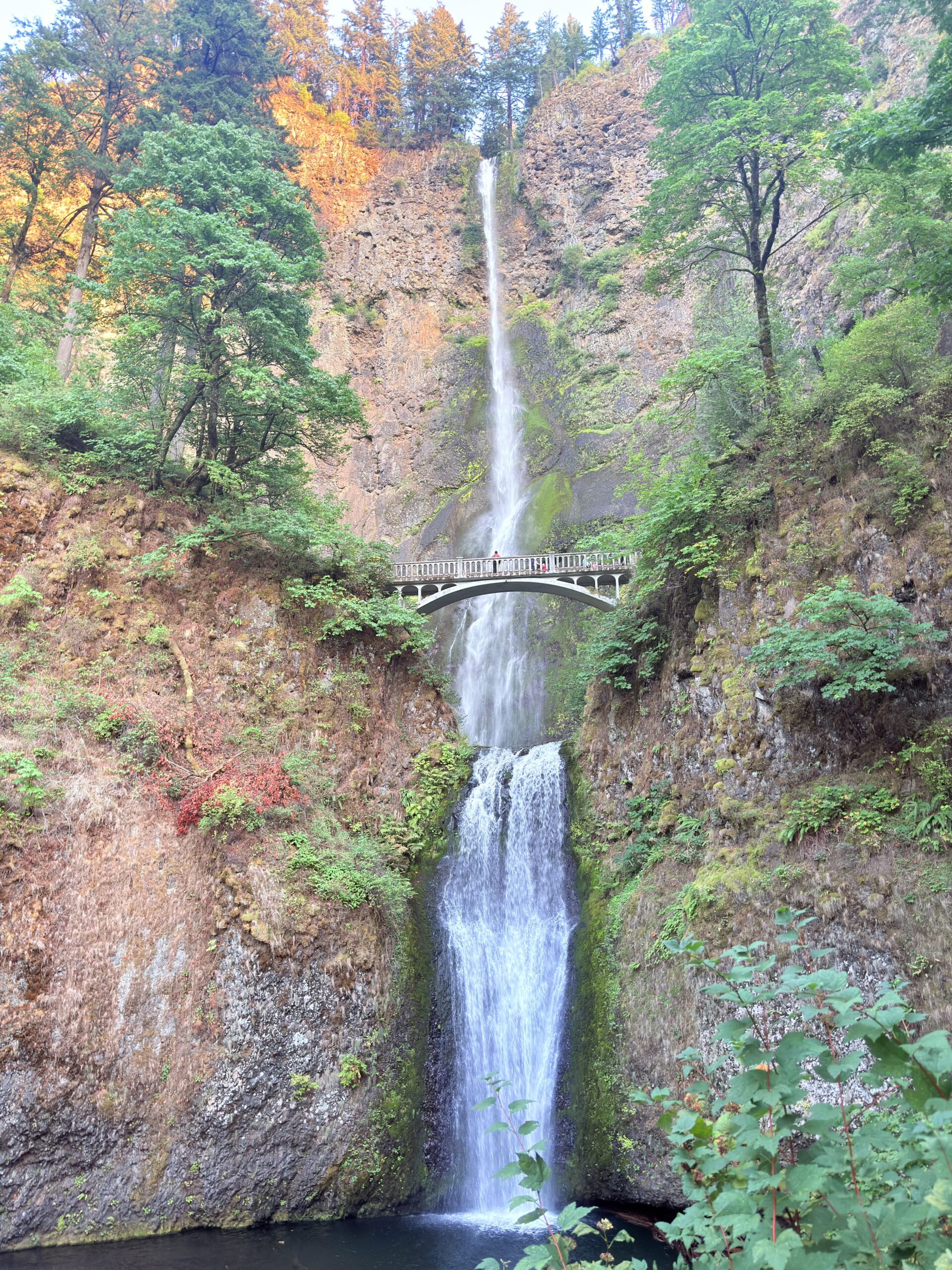
Before sunset, we still managed to visit the breathtaking Multnomah Falls, which I truly recommend seeing in autumn, ideally just before sunset. That kind of beauty is almost impossible to put into words. At 189 meters (620 feet), Multnomah Falls is the tallest year-round waterfall in Oregon. It was formed by massive floods at the end of the last Ice Age, known as the *Missoula Floods*, which dramatically carved the landscape of the Columbia River Gorge. The iconic Benson Bridge, located between the upper and lower tiers of the falls, has stood here since 1914 and was built specifically so visitors could experience the waterfall up close—back when traveling through this area was still a true adventure.
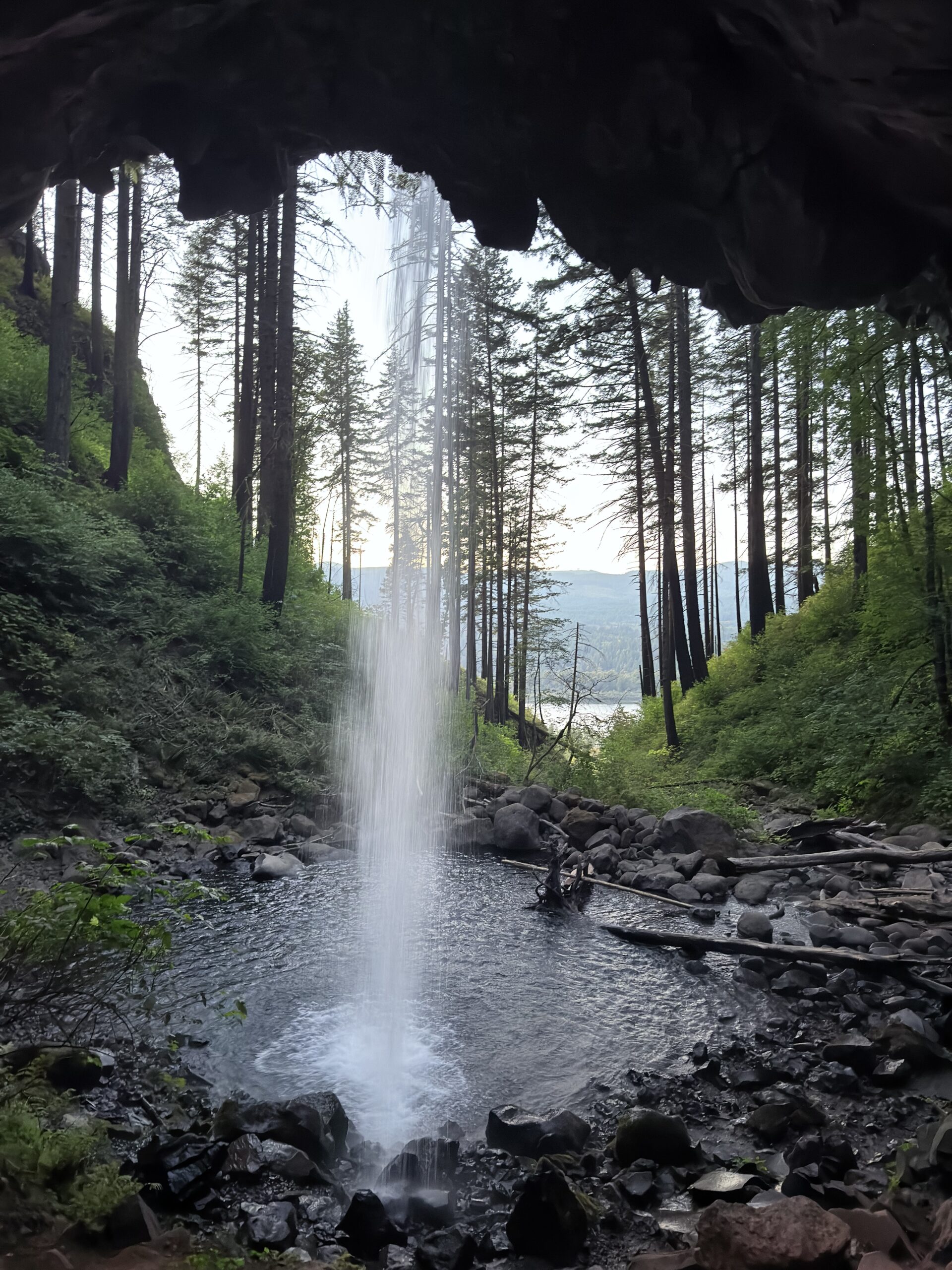
We then continued on to Ponytail Falls and Horsetail Falls. Horsetail Falls is basically right next to the road, with seating nearby, making it a perfect spot for a snack or some quiet reading. Ponytail Falls requires a short trail, but it’s absolutely worth it—it’s one of those waterfalls you can walk behind, so you get to see it from every angle. Our timing worked out perfectly, and we made it back to the car while it was still light, which we honestly hadn’t expected.
For the night, we headed to the Eagle Creek Trailhead, where we gave our heads another quick shave after discovering a few stubborn leftover strands of hair.
Day 2 (September 19, 2025)
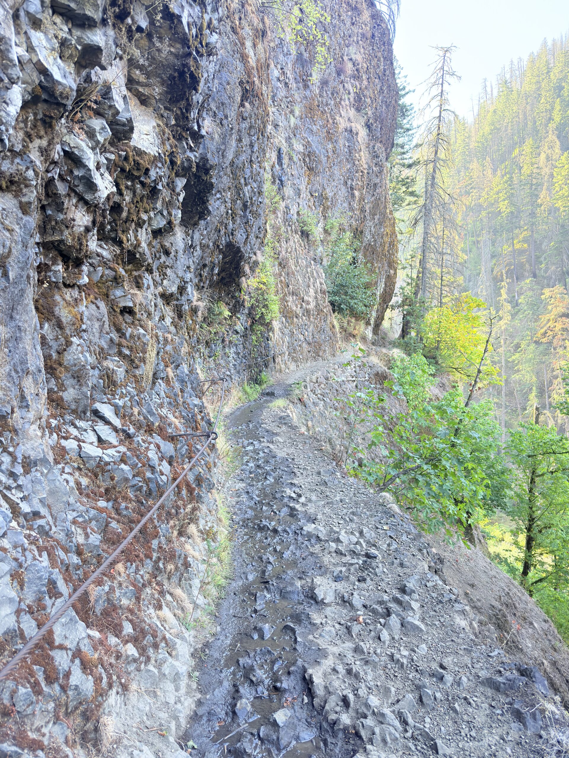
Tunnel Falls / Eagle Creek Trail (20.17 km | 445 m ↑ | 445 m ↓)
On our second day in Oregon, we set out for a slightly longer hike so we wouldn’t completely fall out of rhythm. We tried to start relatively early to avoid getting roasted later in the day. The entire trail is engaging from start to finish, with plenty to look at along the way. We couldn’t wait to reach the tunnel beneath the waterfall itself, but the many waterfalls along the route made the hike fly by.
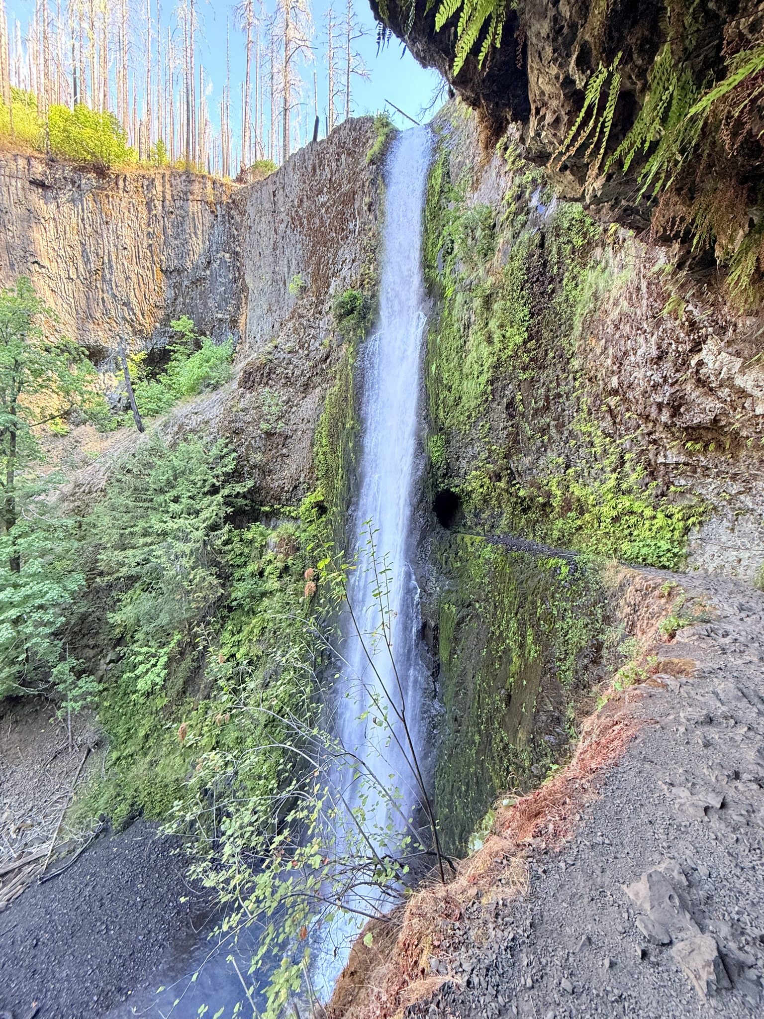
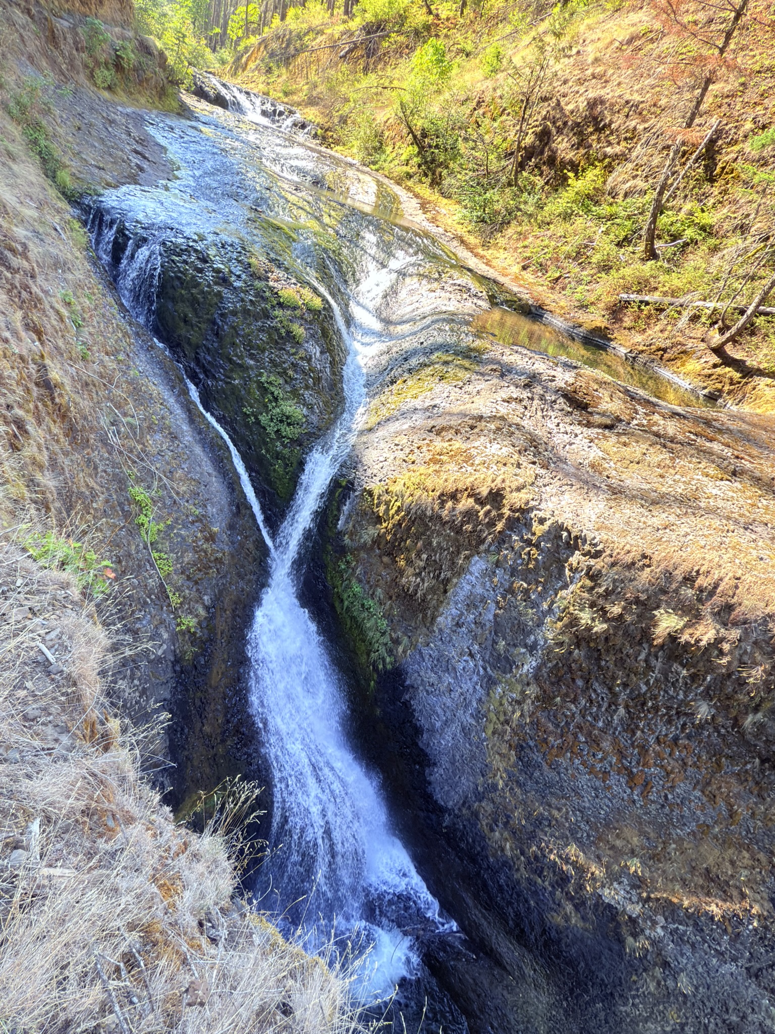
But wow… Tunnel Falls? This is once again something that simply can’t be put into words. I tried to capture it with videos and photos, but even those don’t fully convey its beauty. The tunnel behind Tunnel Falls was carved in the early 20th century as part of the Eagle Creek Trail, originally built to give access to remote areas of the Columbia River Gorge. Walking through the tunnel feels dramatic today, but it was once considered purely practical trail engineering—function first, magic later. We continued on to Twist Falls, and I have to say—someone really put thought into naming the waterfalls along this trail. They truly live up to their names.
We returned to the car just in time for a late lunch, which we first had to cook. While doing so, we called our friend Barča because we needed all the details about her engagement. After about an hour—during which we still didn’t manage to say everything, but it was already quite late in the Czech Republic—we headed off to Vista House for well-deserved views and a coffee or hot chocolate.
Little bit of history:
Vista House was built in 1918 as a memorial to Oregon pioneers and is often called the “crown jewel” of the Columbia River Gorge. Despite looking like a European castle, it was designed as a rest stop for early motorists—proof that scenic road trips were a thing long before Instagram.
After a short stop, we made another brief detour to Timberline Lodge, famous for being used in the film The Shining, and, more importantly, to admire the views of Mount Hood. In winter, this area turns into a ski paradise, and it’s also where the Pacific Crest Trail passes through.
Little bit more of history:
Timberline Lodge was built in the 1930s as part of the New Deal and is one of the few lodges from that era still operating today. Thanks to its elevation, it has one of the longest ski seasons in North America—sometimes you can ski here even in summer.
To end the day, we moved as close as possible to Sahalie Falls, knowing that the following day would be packed and we wanted to make sure we could do everything while it was still light.
Day 3 (September 20, 2025)
Tamolitch Blue Pool (7.23 km | 132 m ↑ | 132 m ↓)
Garfield Peak (3.11 km | 157 m ↑ | 157 m ↓)
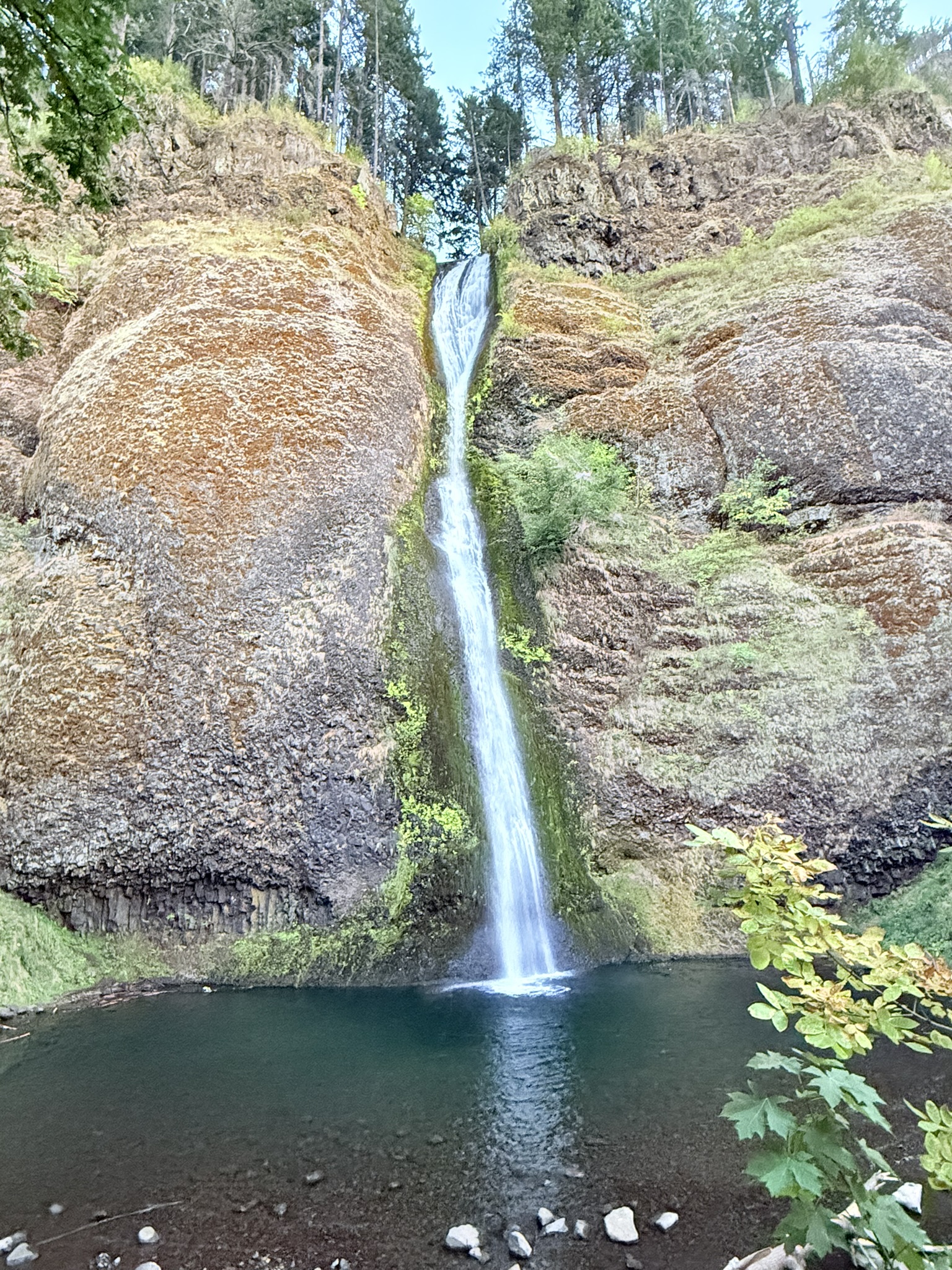
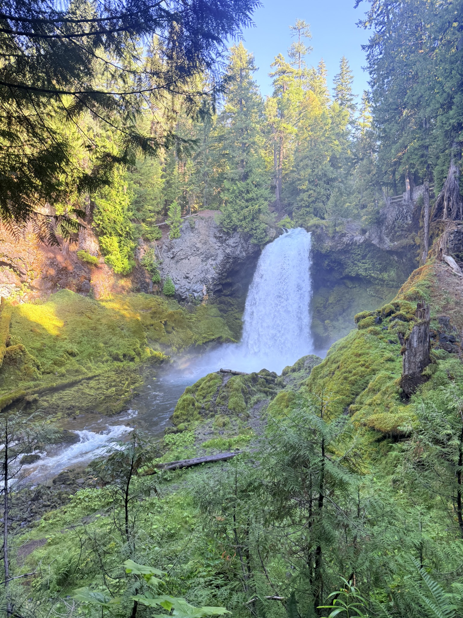
We start our third day at Sahalie Falls, an impressively powerful waterfall surrounded by vibrant, almost unreal shades of green. This is one stop I would absolutely not skip when visiting Oregon—and the bonus is that it’s just a few steps from the parking lot. Sahalie Falls gets its name from the Chinook Jargon word “sahali,” meaning “heaven.” The waterfall is fed by the McKenzie River, which is largely sustained by underground lava flows, giving the water its intense color and consistent flow year-round.
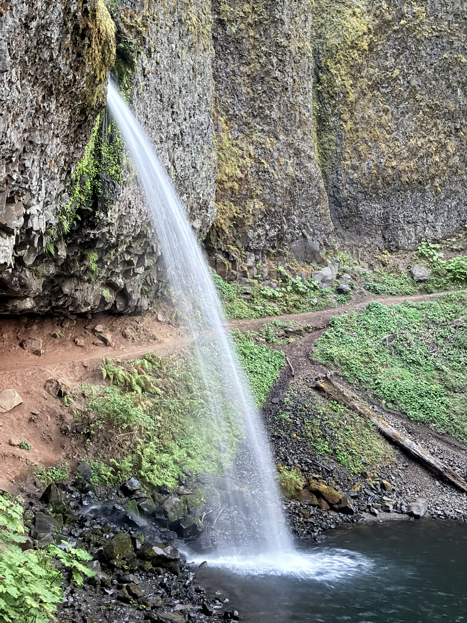
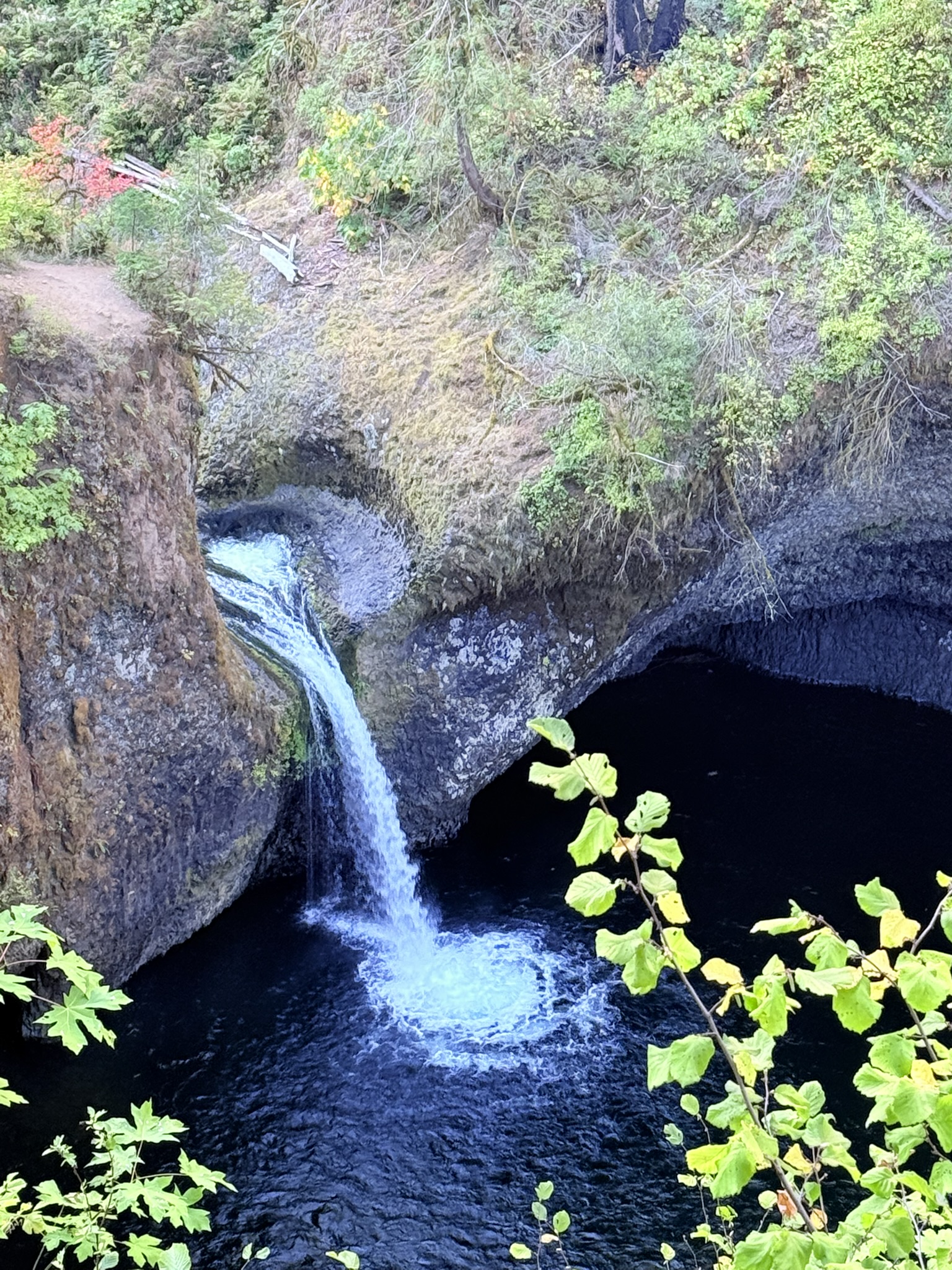
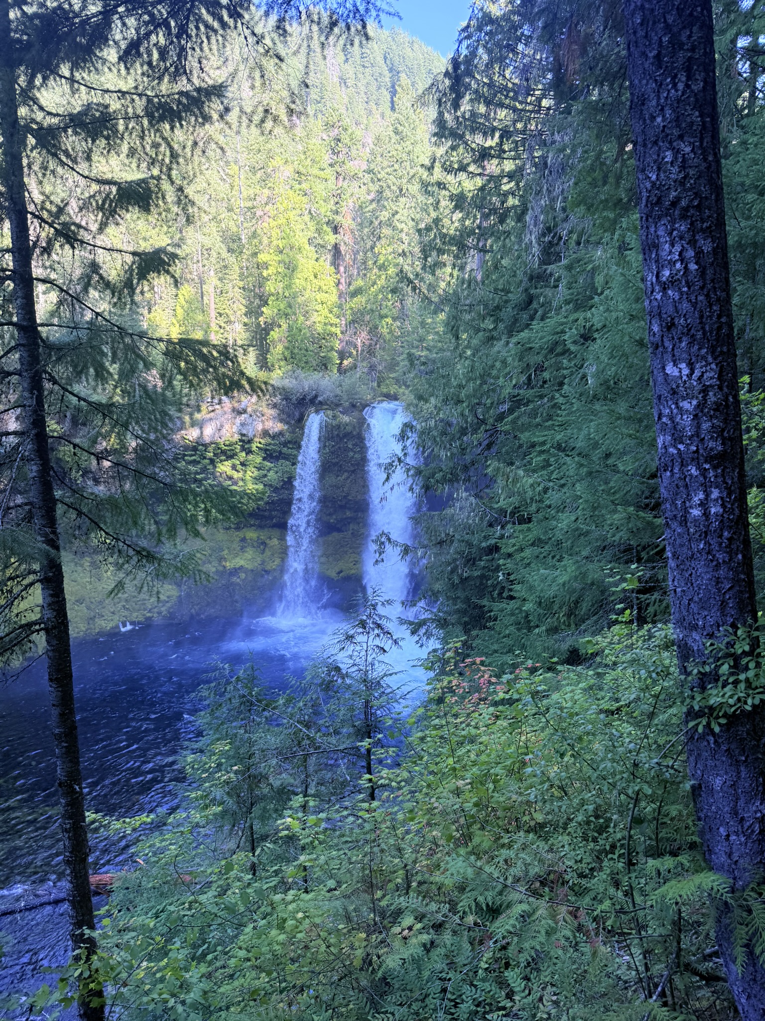
We then continue to Koosah Falls, located just a short distance from Sahalie. If you want to stretch your legs, you can walk between the two waterfalls via a scenic trail. It’s an out-and-back route, though, so you return the same way. We chose to drive instead—to save time and, frankly, my Achilles tendons. Koosah Falls is named after another Chinook word meaning “sky.” While often overshadowed by Sahalie, many locals consider Koosah more dramatic due to its narrower chute and the way the water crashes into a deep basalt pool below.
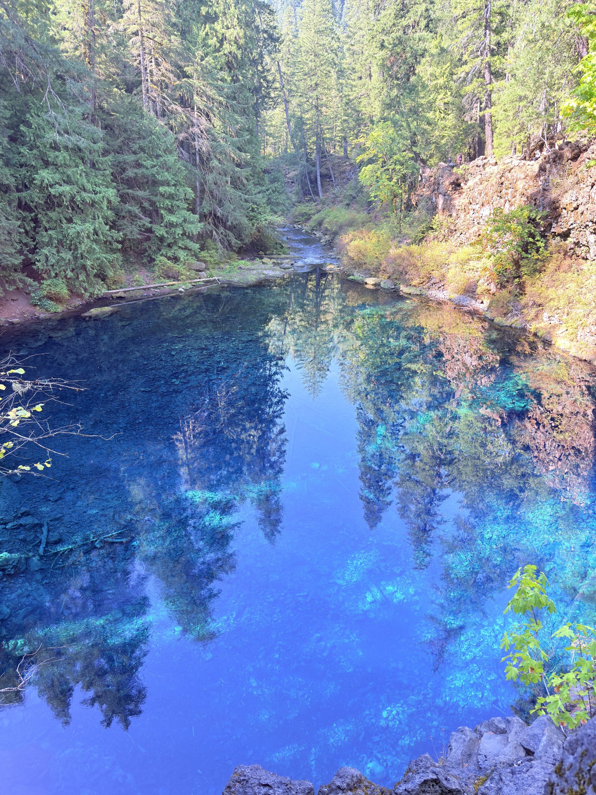
Next up is Tamolitch Blue Pool, a place I had been ridiculously excited about after seeing countless photos and videos—crystal-clear, intensely blue water that you can technically swim in (ice-cold, obviously… haha). The trail to the pool is about 7 kilometers long. You can make it into a loop, with one section designated for bikes. Since we didn’t encounter a single cyclist, we took the bike path, ready to step aside if needed—but it stayed blissfully quiet. The striking blue color isn’t just for show. The McKenzie River disappears underground for several kilometers due to ancient lava flows and re-emerges here, naturally filtered and icy cold—often just a few degrees above freezing. That’s why the water looks tropical but feels… aggressively alpine.
Heading toward Cougar Reservoir, we considered visiting Terwilliger (Cougar) Hot Springs, which Brett had recommended. However, we quickly realized how popular it is—the parking lot was packed, and the entrance fee was $12 per person. That felt a bit overpriced, especially since many hot springs in the U.S. are free or only charge for parking. Our next stop, Umpqua Hot Springs, also recommended by Brett, costs just $5 per car, so we decided to skip Terwilliger. Instead, we enjoyed a scenic drive through the area, soaking in mountain and water views.
The road to Umpqua Hot Springs is a rough service road, but the destination is absolutely worth it. From the parking lot, it’s only a few hundred meters to the pools—some sections are quite steep, so sneakers are definitely a better idea than flip-flops (which we stupidly wore). Getting into the top pool, the hottest one, was… a challenge. It’s very hot. The lower pools, though, are wonderfully comfortable, and there’s no need to be disappointed if the upper pools are full—there are plenty more cascading down toward the river.
More practical information about the Hot Springs:
Umpqua Hot Springs sit on a cliff above the North Umpqua River and consist of multiple naturally terraced pools. The water emerges at around 40–45°C (104–113°F) and cools as it flows downward, letting you choose your preferred level of “how much heat is too much.”
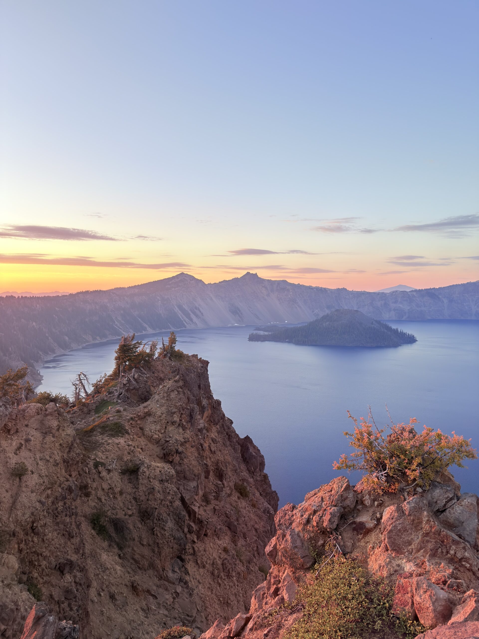
As if that still wasn’t enough for one day, we headed toward Crater Lake, with the goal of hiking Garfield Peak specifically for sunset. Surprisingly—and unfortunately—we didn’t quite make it to the summit in time, even though we were moving fast. Luckily, the trail offers several spots where you can stop, sit down, and enjoy a spectacular sunset anyway—even if it’s not from the very top. Crater Lake is the deepest lake in the United States and was formed after the collapse of Mount Mazama nearly 7,700 years ago. There are no rivers flowing into or out of it—the lake is filled only by rain and snow—making its water some of the clearest and bluest in the world.
Day 4 (September 21, 2025)
On the fourth day, we were planning to hike South Sister, but it didn’t occur to me that a reservation is required in advance. In the U.S. and Canada, reservations are usually needed mainly for campsites, but here they are also trying to redirect hikers to other, less-visited areas and thus “relieve” this trail a bit.
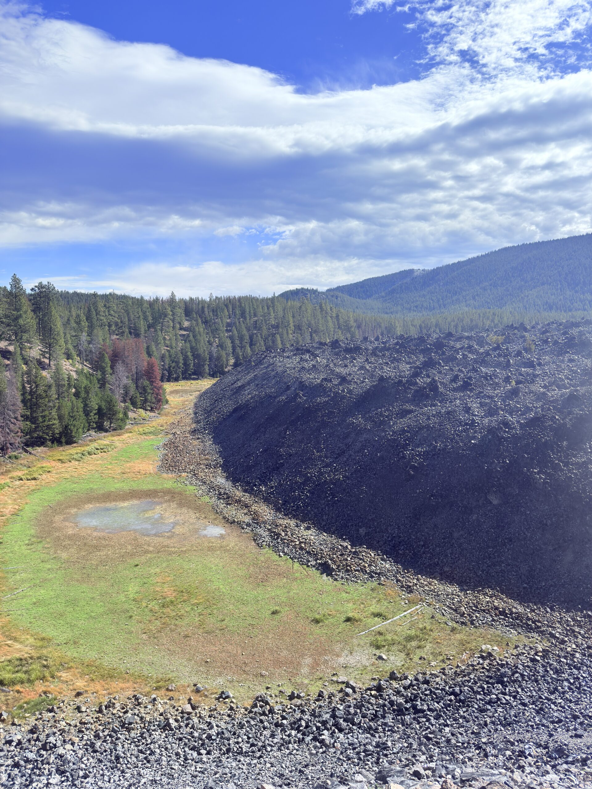
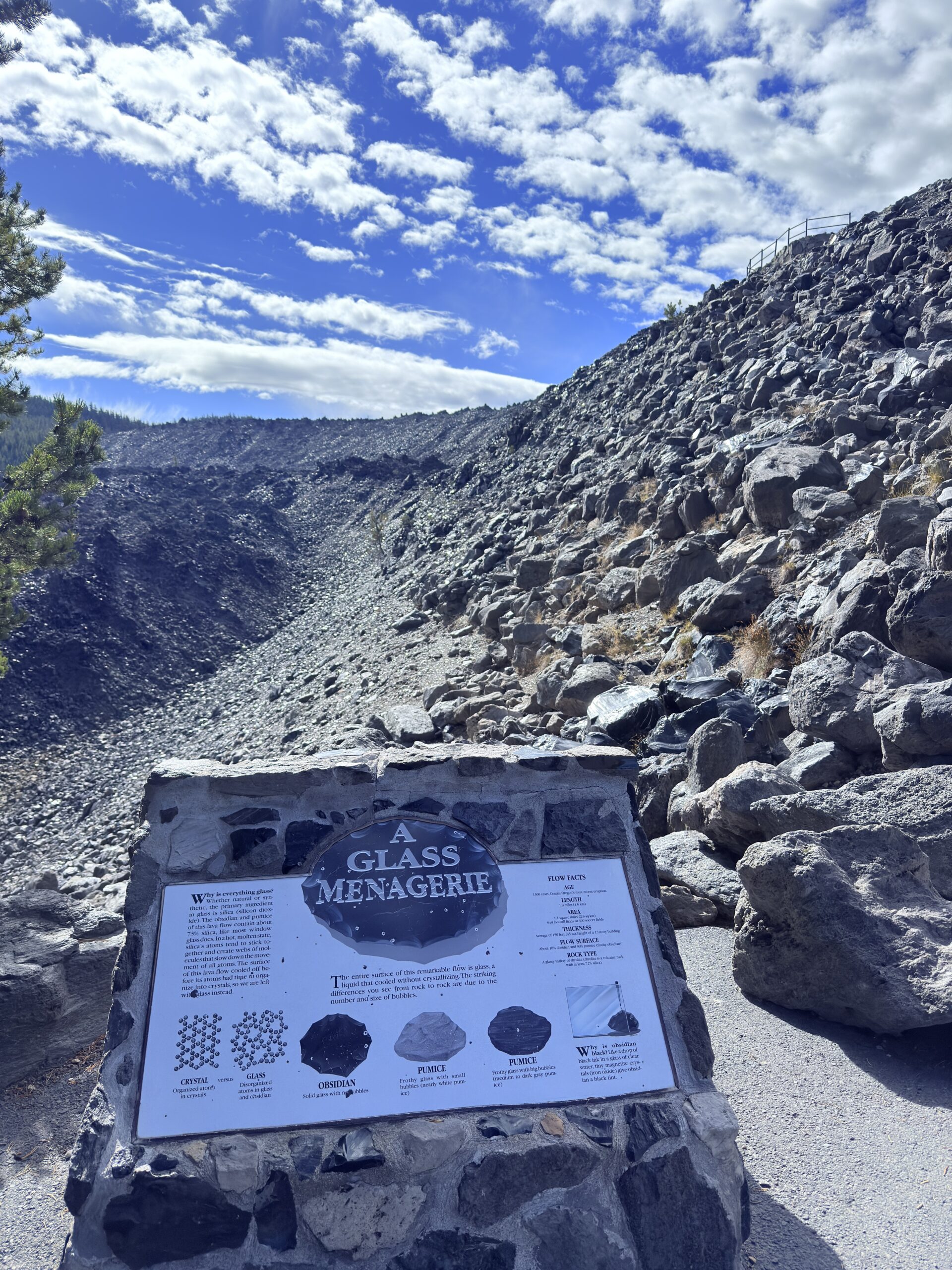
Because of this lack of information, we met Jess, who also didn’t have a reservation, and we agreed that we could hike the trail together the following day. The weather didn’t look very pleasant anyway, so we sorted out a reservation for the next day and decided to hike Big Obsidian Flow today, which Denča had recommended.
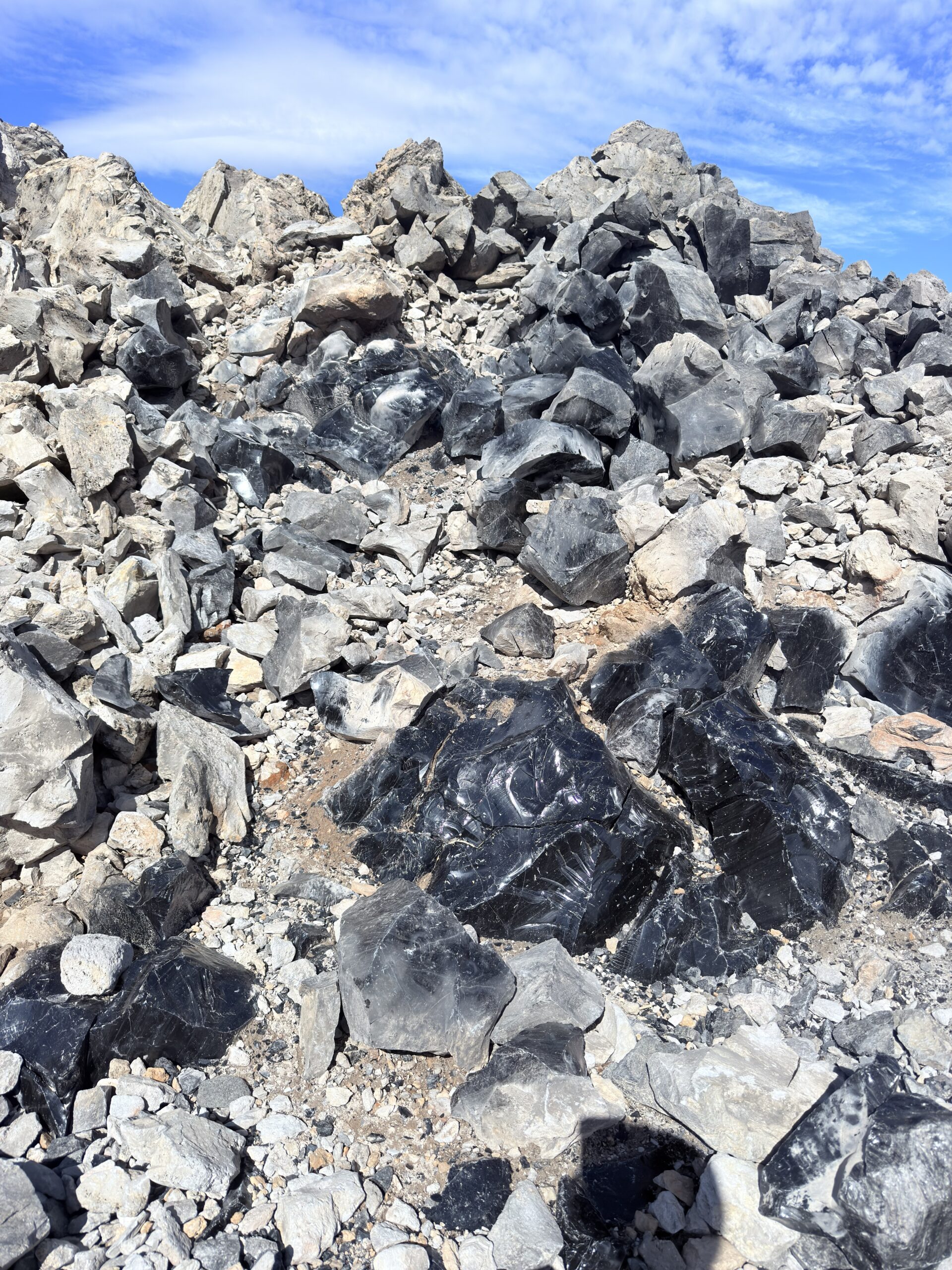
Big Obsidian Flow is one of the largest continuous obsidian flows in North America. It was formed during an eruption roughly 1,300 years ago, when extremely viscous lava cooled so quickly that it didn’t have time to form crystals—and instead turned into volcanic glass. Obsidian is so sharp that Indigenous peoples of the area used it for arrowheads and knives, and archaeological finds from this source have been discovered hundreds of kilometers away. What’s also fascinating is that the surface of the flow can heat up significantly in the sun, so even on a cooler day it can feel surprisingly “summery”—a perfect place to realize just how alive and recent the volcanic history here really is.
We then continued to Pilot Butte, which you can reach by car, on foot, or by bike. Given the rain, we chose to drive. From Pilot Butte, we called Lu’s grandmother and ended up enjoying what turned into a relatively easy-going day.
We still had a laundromat ahead of us, where we spent more than two hours, but we used the time to plan some sections of the road trip in more detail. In the evening, it was just grocery shopping, getting closer to the trailhead, cooking, and preparing for the following day, because we wanted to set off early. It was already cold in the evening, so we knew we wouldn’t feel like packing in the morning—and definitely didn’t want to leave everything until then.
Day 5 (September 22, 2025)
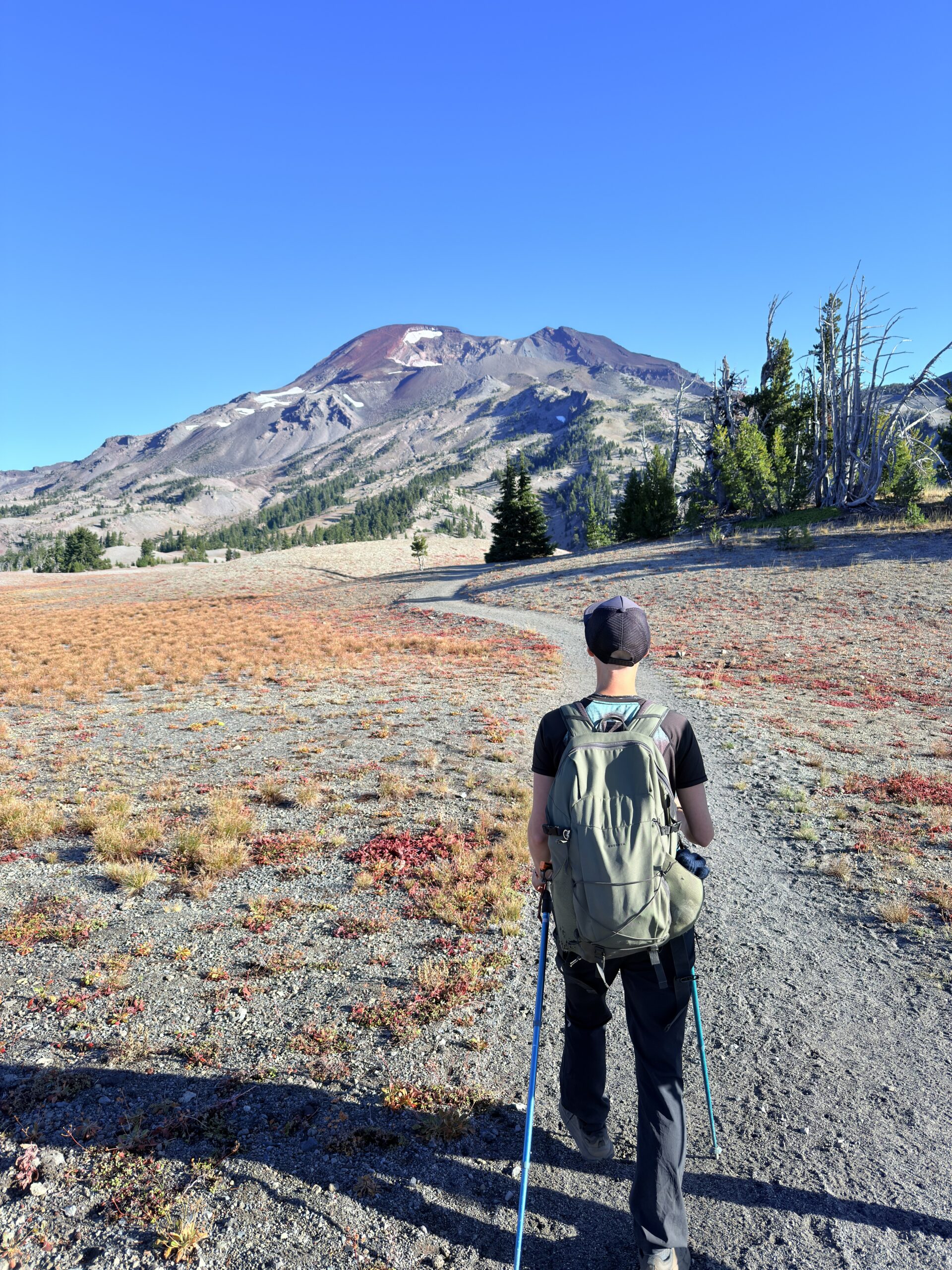
South Sister Summit (19.89 km | 1 605 m ↑ | 1 605 m ↓)
We wake up while it’s still dark, and it’s unbelievably cold. We meet Jess at the trailhead, and all of us are absolutely freezing, so we try to get moving as quickly as possible. As soon as the sun comes up, we gradually start peeling off the layers we piled on in the morning. I won’t lie—the trail is quite demanding. The distance is “only” about 20 kilometers, but an elevation gain of 1,605 meters definitely doesn’t come for free.
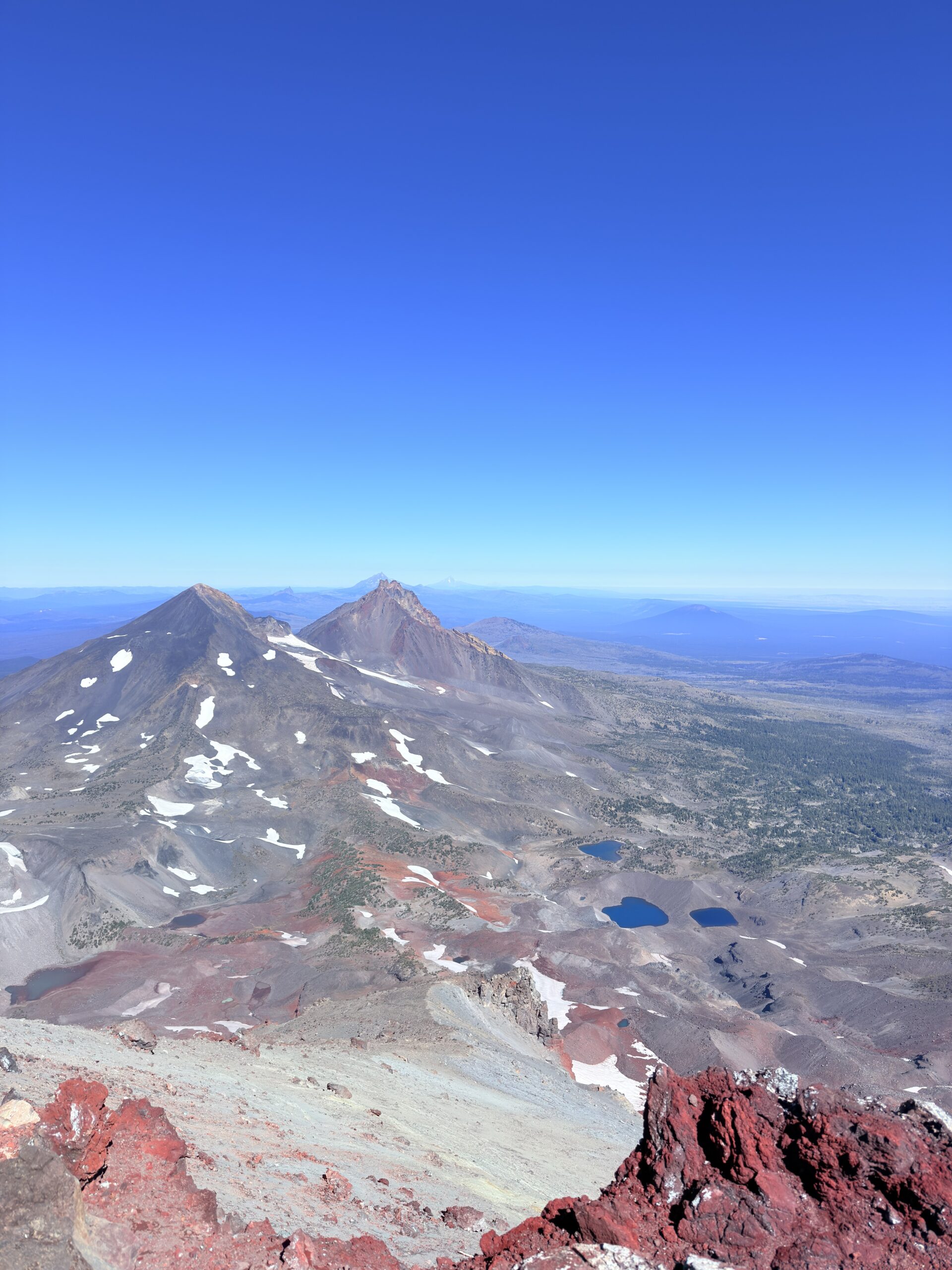
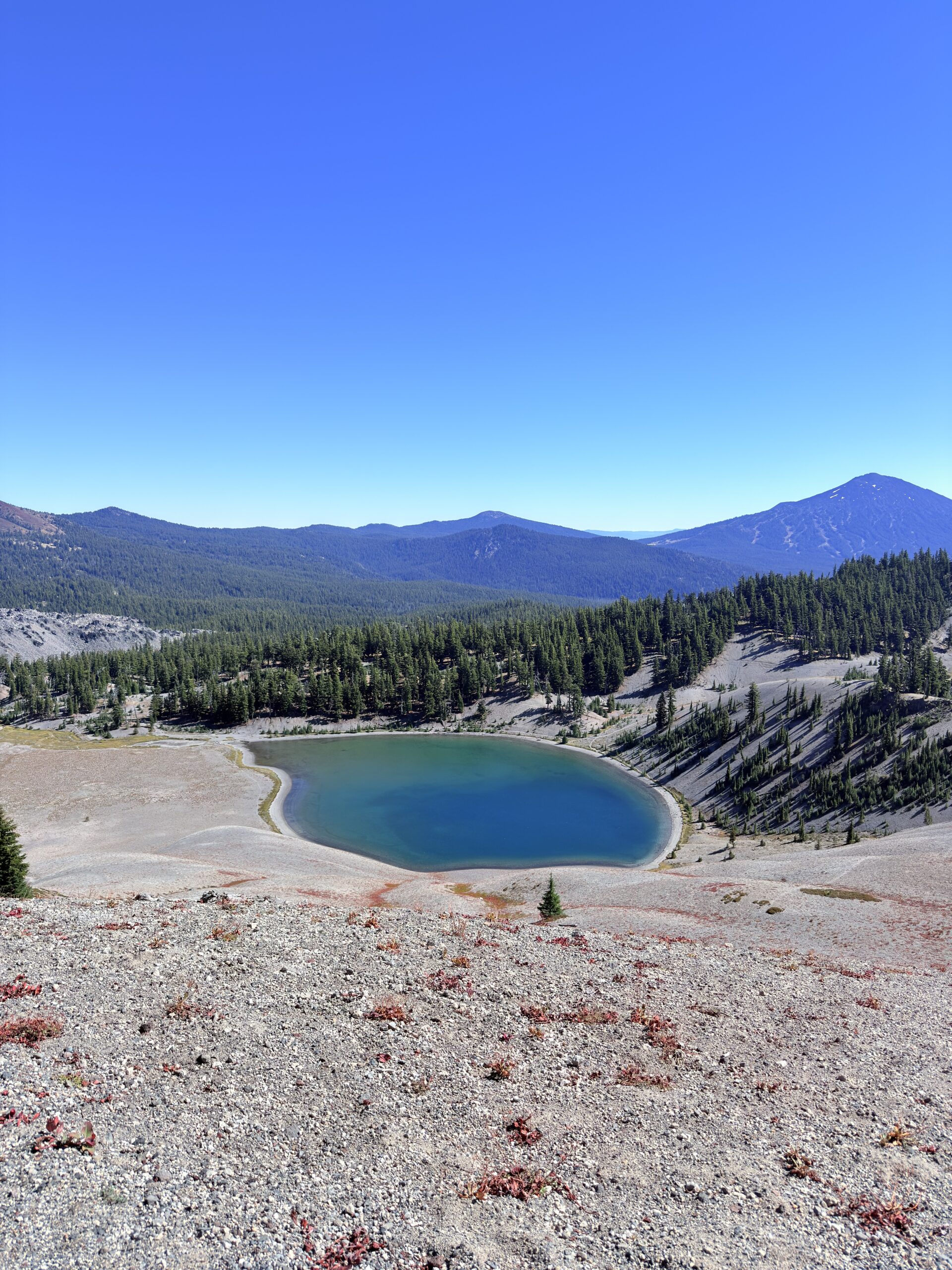
Once we climb out of the forest, though, we’re rewarded with views—first of lakes, then of the summit we’re heading toward, and later of glaciers and glacial lakes. I honestly don’t wonder at all anymore why this trail is so popular.
After finishing the hike, we’re starving, so we cook food right there in the parking lot. We really clicked with Jess—we talked the entire way because we’re all on the same wavelength. We agree that we’ll definitely meet up again later when we pass through Utah, where Jess currently lives.
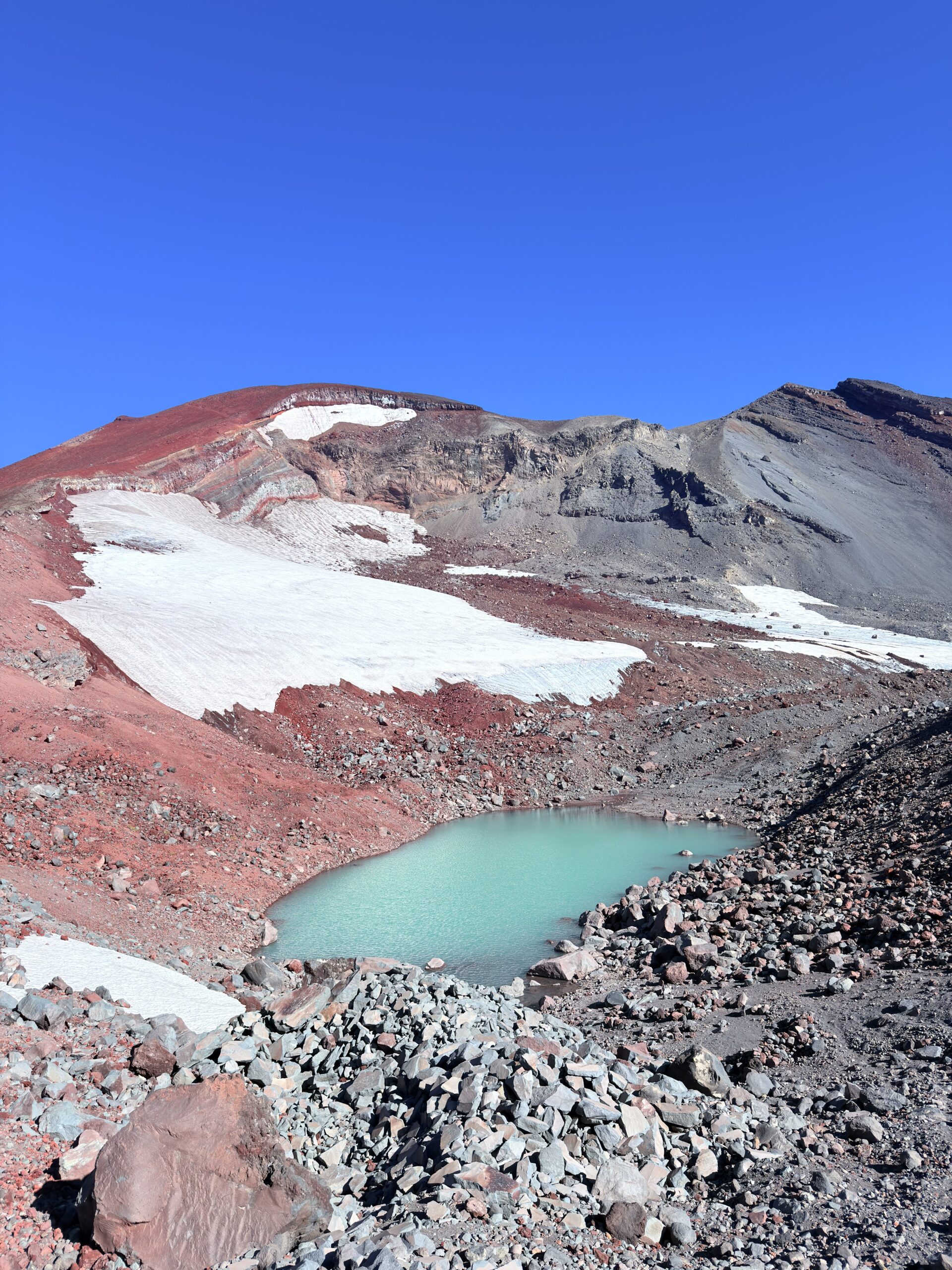
South Sister is the tallest of the Three Sisters volcanoes and the third-highest mountain in Oregon (3,158 m / 10,358 ft). Although it looks peaceful, it is a stratovolcano that is still considered potentially active, with its last eruption occurring about 2,000 years ago. The summit area is famous for its large obsidian lava flows and offers some of the most stunning views in the entire state.
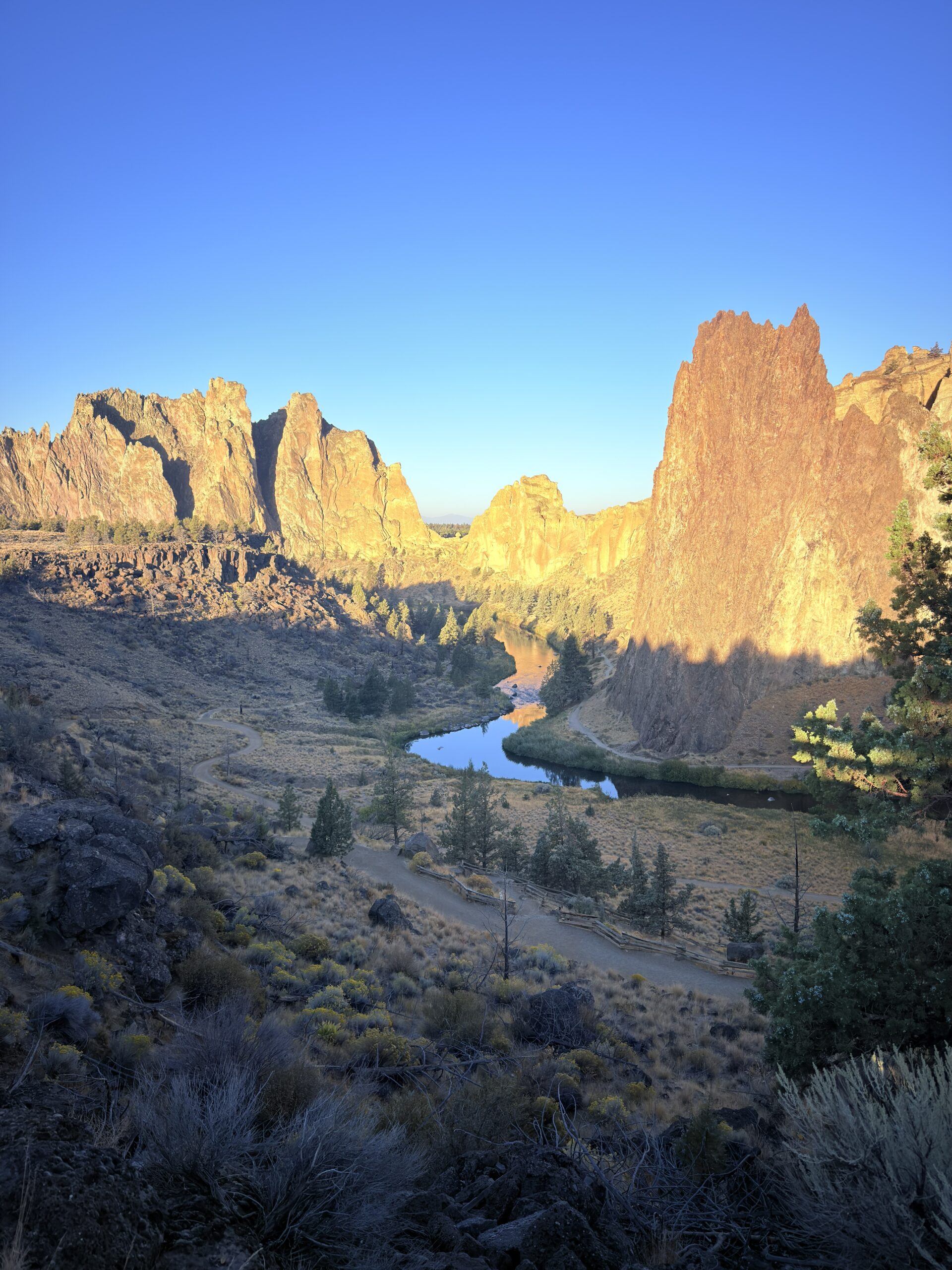
In the evening, we simply move on toward Smith Rock State Park, one of our last stops in Oregon.
Day 6 (September 23, 2025)
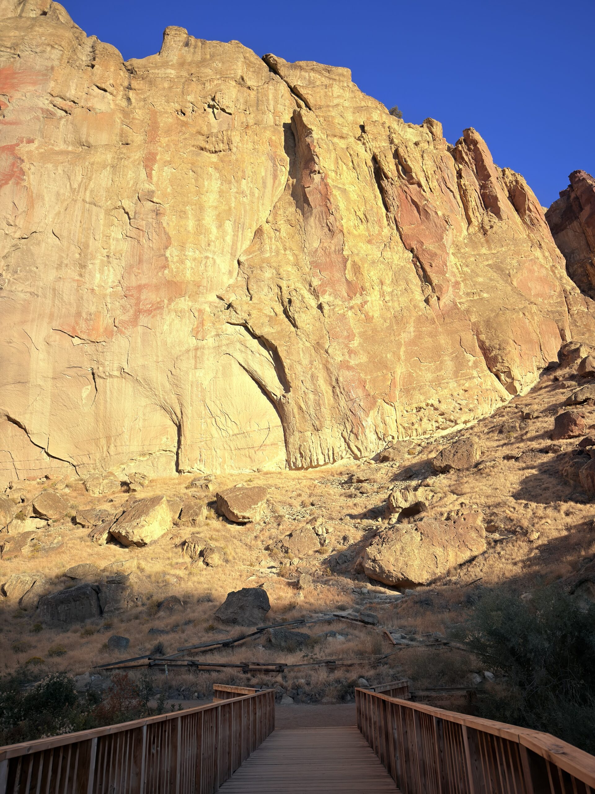
Smith Rock State Park (6.07 km | 321 m ↑ | 321 m ↓)
We start the morning with breakfast, of course, and then head out for a walk in Smith Rock State Park, which was also recommended to us by Denča. We usually prefer national parks, because you can buy an annual pass and don’t have to pay for each individual entry. On the other hand, state parks typically charge an entrance fee per car, usually ranging from 5 to 15 USD. Honestly, there are state parks that aren’t worth even those 5 dollars, but that’s definitely not the case with Smith Rock State Park. We choose a shorter loop since we’re a bit short on time, but even so, we really enjoy this place. The park also has areas where people can go rock climbing. If I lived nearby, I would definitely buy an annual pass.
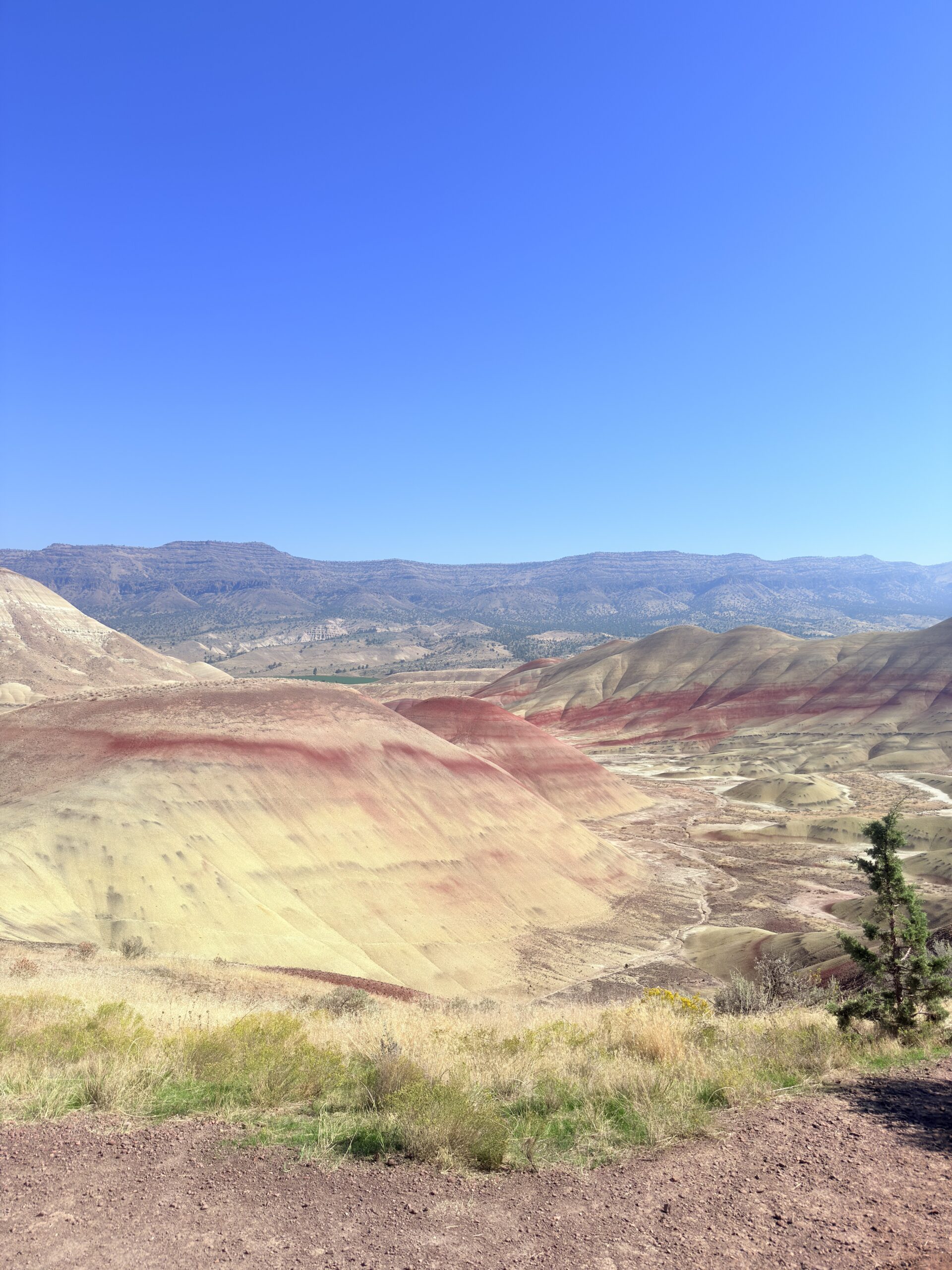
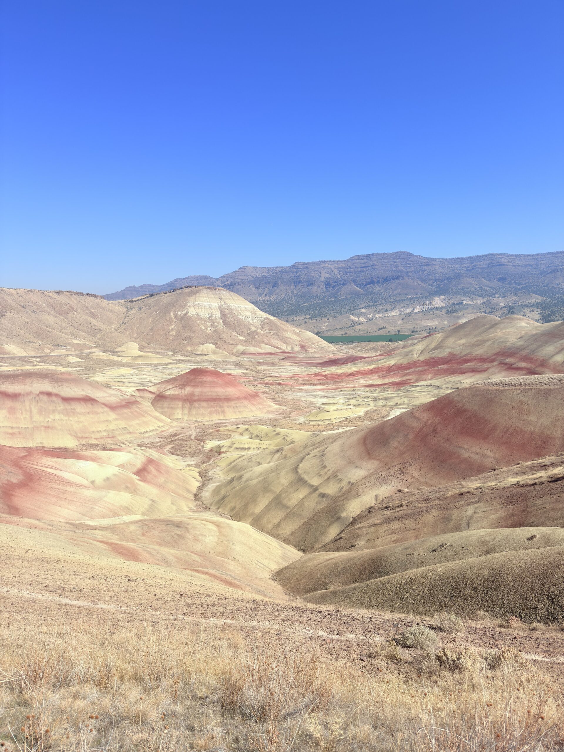
Our last stop in Oregon is at the Painted Hills, whose name is perfectly fitting. These hills truly look as if someone had painted them by hand. Painted Hills are one of the three units of John Day Fossil Beds National Monument, and their colorful bands were formed by the gradual deposition of volcanic ash and sediments over millions of years. The individual shades of red, yellow, gold, and black stand out best after rain or in low sunlight, when the hills truly look as if they were hand-painted.
Now all that awaits us is the boring remainder of the day in the form of a drive to Idaho, whose article you can look forward to next month.
Approximate expenses for the whole 6 days and 2 people:
· Gas = $219
· Food = $138
· Permits/Entrances = $12
· Other = $90
TOTAL: $459 (38USD/person/day)